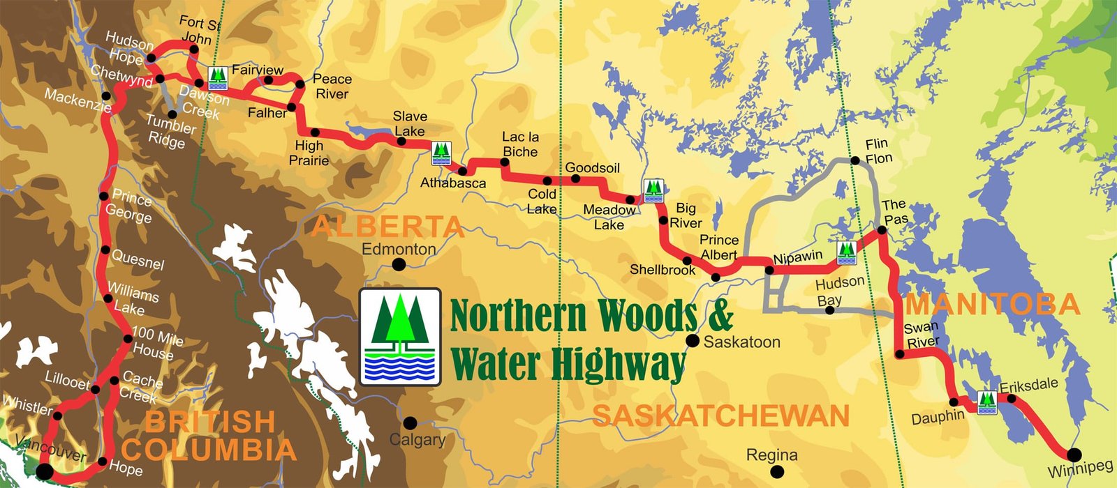
2027 West to East Cavalcade
Please note that this itinerary is a draft and subject to change dates and destinations
Click on the Day below and a detailed description will open.

The Fraser River passes through town and the junction of three highways: Hwy #1 from the Fraser Canyon, Hwy #5 Coquihalla, and Hwy #3 Crowsnest. The Sylvester Stallone movie Rambo - First Blood was shot in Hope and there are still movie fans coming to Hope to see where some of the scenes were shot.
Arrive early and explore around town. Meet your Cavalcade leaders at the campground and gather together for our 1st meal together at 6:30.
This is the start of a 21-day exploration of the northern parts of the four western provinces. From this point on we will travel 200-250 km per day.
Meet and Greet


Flood Falls - 8 km west of Hope

Hope Golf Course
Camping
Telte-Yet Camp Site
Coquihalla Campground
Supper
TBA

Marmot spectators Hope Golf course

Chainsaw Carvings around town
Golf
Hope Golf Course
History
Rambo First Blood Movie - Sylvester Stallone
Activities
Chainsaw Carvings
Nature
Flood Falls - 8 km west of town

The first travel day will have us on Hwy #1 through the Fraser Canyon passing several smaller communities: Yale, Boston Bar, at Lytton the highway turns eastward away from the Fraser River then through Spences Bridge, Ashcroft and into Cache Creek. The route has lots of twists and sharp corner and travel will be slower but pictureque. We will be staying at the Hat Creek Historic Village 10 km north of Cache Creek. Supper will be served at the restaurant on site at 6:30. Take your time to explore.

193 km travel
Camping: Hat Creek Ranch - Junction Hwy 99 & 97
Supper: Hat Creek Ranch - 6:30 p.m.
Sani Dump: Cache Creek Info Centre


Horsting's Farm Market


Museums
Ashcroft Museum
Bonaparte Church
Hat Creek Ranch
Activity
Horsting Farm Market

The day's travel is through the historic Cariboo Gold Rush area. Travel through Clinton, past the Chasm Ecological Reserve, then 70, 100, 108, Mile Houses. The various communities with Mile in their name are based on the distance from Lillooet, Mile zero of the Cariboo Wagon Road. They were stops to change horses, rest, and grab some grub. There is a great golf course at 108 ranch.

127 km travel
Camping
108 Ranch Golf Campground
Supper
The Eatery

Clinton

Chasm

100 Mile House Bridge Creek Falls

108 Mile House Heritage Site

Golf
108 Golf Resort
Museum / History
Clinton Museum
108 Ranch Heritage Site
Activities
Fishing 108 Mile Lake
Nature
Chasm Ecological Reserve
Bridge Creek Falls - 100 Mile House

79 km travel


Lac la Hache


Willams Lake Stampede Campground
Camping
Stampede Grounds Campground
Junction Hwy 97 and 20
Supper
Stampede Grounds
Sani Dump
Stampede Grounds

Great outdoor supper

Museum / History
108 Ranch Heritage Site
150 Mile School House
Museum of the Cariboo Chilcotin
Activities
Scout Island Nature Centre

Travelling south from Prince George we will pass through Hixon which has a short drive and hike to Hixon Falls just west of town. Then it is onto Quesnel. Approx 9 km west of Quesnel is the Pinnacles Provincial Park which has some unique geological formations. We will stay at Robert's Roost campground as a base for two days and our bus trip to Historic Barkerville the following day.

121 km travel


Hixon Falls

Pinncles Prov Park 9 km west of Quesnel

Billy Barker at Quesnel Information Centre & Museum

Nature
Hixon Falls
Pinnacle Provincial Park


Bus Trip
Rather than taking the RVs to the Barkerville Historic Town 90 east of Quesnel and back. We will bus there for the day and return to Robert’s Roost Resort for the 2nd evening. This is a long day, the bus starts in Quesnel at 7 am and arrives at Barkerville at 8 am. We will have breakfast and supper on site before returning to Quesnel at 6 pm.

Barkerville Hattery

Blacksmith Demonstrations

Interpretive Tours in Costume

Stagecoach Rides
Camping: Roberts Roost Resort on Gook Road
Supper: Roberts Roost Resort
Sani Dump: Roberts Roost


Museum / History
Barkerville Historic Town
Activities
Interprerative Tours
Stagecoach Rides
Blacksmith Demonstrations
Theatre Presentation
Nature

196 km travel

Hixon Falls


229 km travel


Bus Trip 180 km Tumbler Ridge
70 km RV travel Hudson's Hope


101 km travel
The day includes a short bus trip and a tour of the WAC Bennett Dam before returning and picking up camping units and travelling along the bottom of the Peace River Valley popping up near Charlie Lake. On the northside of Fort St. John, a viewpoint overlooks the Site C Dam. We drop down into the river valley again at Taylor. There is an excellent 18-hole golf course at Taylor. Dawson Creek is our destination for the day. It is Mile Zero of the Alaska Hughway.


Peace River Valley

Charlie Lake Campground

Site C Dam - FSJ Viewpoint

Fort St John Museum

Taylor Valley
Camping: Dawson Creek
Supper: TBA
Sani Dump: Mile Zero Campground
Dawson Creek is Mile Zero on the Alaska Highway which was hastily built during WW 2. Stop at the info centre on the east side of the city and learn some history of the Highway, possibly tour the Walter Wright Pioneer Village while in town.

Mile Zero Post - Dawson Creek

Golf
Moberley Lake Golf Course
Lakepoint Golf & CC - Charlie Lake
Fort St John Links Golf
Lone Wolf Golgf - Taylor
Farmington Fairways
Dawson Creek Golf & CC
Museum / History
Hudson's Hope Museum
Fort St John Museum
Walter Wright Pioneer Village
Dawson Creek Museum & Info Centre

From the traffic circle on the east side of Dawson Creek, head east on Hwy 49, it is a short trip to the Alberta border and cheaper fuel. At Rycroft turn north 22 km to the historic Dunvegan Bridge, then onto Fairview, Berwyn, Grimshaw and into Peace River. The days travel is a loop that will cross the Peace River at Dunvegan and again at Peace River. The river flows north from here to the Northwest territories and eventually the Arctic Ocean.
Extra hours of summer sunlight provide excellent agricultural growing condition in Alberta's Peace River region.
Easy access to the water in the Town of Peace River from the boat launch in Lower West Peace.

130 km travel


12 foot Davis

Local Deer watching you

Peace River Valley in fall colours

Camping in Peace River
Golf
High Prairie Golf
McLennan Golf
Heart River Golf - Nampa
Mighty Peace Golf
Museum / History
High Prairie Museum
McLennan RR Museum
Societe Historique et Genealogique Smoky River
Peace River Museum & Archives
Activities
Walking Trails
River cruise
Jet Boat races in July
Nature
Peace Valley - Dunvegan, Peace River


245 km travel


The days travel is predominantly through the northern boreal forest with some agricultural land still being carved out. Athabasca is a riverfront community in the valley. There is a farmers market at the riverfront park on summer weekends. The larger community golf courses are 18 hole challenges with lots of trees and water plus elevation chagnes.

228 km travel

Camping
Bold Centre Campground
Beaver Lake Campground
Supper
TBD
Sani Dump
By the Bold Centre

Athabasca Riverfront
Lac la Biche Mission Historic Site

David Thompson Monument
Lac la Biche Golf Course
Golf
Gilwood Golf - Slave Lake - 18 hole
Athabasca Golf - 18 hole
Skelton Lake Golf - 9 hole
Lac la Biche Golf - 18 hole
Museum / History
Lac la Biche Mission Historical
Lac la Biche Info Centere Museum
Activities
Boating
Fishing
Beach Time
Hiking
Nature
Sir Winston Churchhill Park
Bird Watching
Hiking


148 km travel


Beaver Lake campground

Hwy 55 between Lac la Biche & Cold Lake

LaCorey Fuel and parking for oil workers travelling north

Golf
Lac la Biche Golf
Grande Centre Golf
Cold Lake Golf & Winter Club


270 km travel


232 km travel


The road east of Nipawin to The Pas is being upgraded. To bypass this rough section, head east on Hwy 55 to Hwy 23 South through Carrot River. Overnight at Pasquia Reg Park which has a nice 9-hole golf course with elevation changes and lots of water, then onto Arbourfield then south to the junction of Hwy 3 East to Hudson Bay, Sk. The road starts in an agricultural area and eventually travels through parkland and into the forest. Hudson Bay has a large Heritage site with a large collection of John Deere tractors. East of Hudson Bay the road is paved but has some rough patches. It connects to Hwy 10 then south to Swan River.
302 km travel


Hudson Bay, Saskatchewan

Swan River, MB

From Swan River, head east, at Cowan there are two options here: 1) join Hwy 20 will take you further east and through Camperville and past Winnipegosis coming into the northeast side of Dauphin. 2) Hwy 10 will take you south parallel to Duck Mountain Provincial Park past Pine River and Ethelbert coming into Dauphin on the northwest side.
171 km travel


Many stocked lakes in Duck Mountain Prov Park


Roadside Blueberry picking near Cowan

Commercial Fishing Boat - Winnipegosis

Dauphin RR Museum
Camping: Swan Valley Museum
Supper: Swan Valley Museum
Sani Dump:

Golf
Swan River Golf
Dauphin Lake Golf Course
Museum / History
Swan Valley Museum
Winnipegosis Museum
Dauphin RR Museum
Fort Dauphin Museum
Activities
Swimming Dauphin Lake
Ukrainian Festival Site - south of Daphin
Nature
Walking Trails Vermilion River Camground

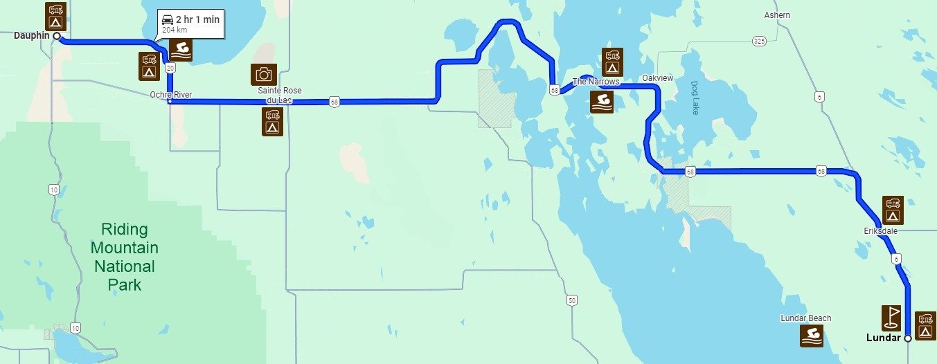
204 km travel


Camping: Lundar Agri Campground
Supper: TBA
Sani Dump:


114 km travel
It is a short journey from Lundar to Eriksdale with lots of time to explore museums or play a round of golf. There are several trails around Lake Manitoba's shores that provide bird watching opportunities.


Lundar Museum

Lundar Marsh Trail

New Lake Manitoba Resort Golf

Grosse Isle Heritage Site
Golf
Lundar Golf
Lake Manitoba Resort
Museum / History
Lundar Museum
Woodlands Museum
Activities
Lundar Beach - Swimming
Lundar Outdoor Swimming Pool
Camping: Grosse Isle Recreation
Supper: Grosse Isle Heritage Site

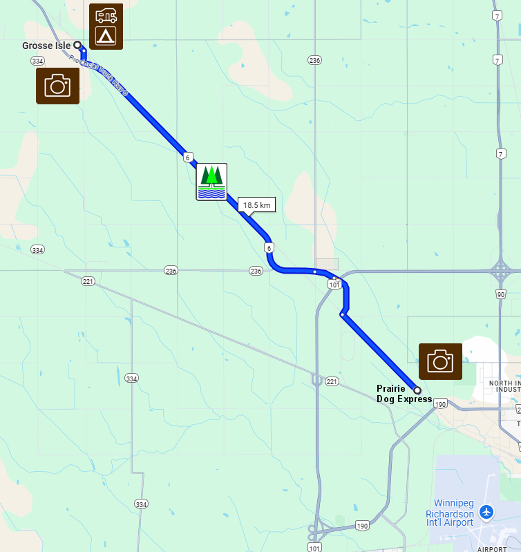
On the weekends during the summer, the Prairie Dog Express makes its way from Winnipeg to Grosse Isle which hosts with entertainment, small vendors and local museum. This is our final adventure for this tour.
20 km travel


Inkster Junction - Winnipeg


Your content goes here. Edit or remove this text inline or in the module Content settings. You can also style every aspect of this content in the module Design settings and even apply custom CSS to this text in the module Advanced settings.
East to West Cavalcade
Details of the itinerary will be released shortly
Camping
Grosse Isle Recreation Area
Supper
Grosse Isle Heritage Site
Meet & Greet
Arrival and the Meet and Greet will start after 4 pm with supper in either the Hall or the Heritage site. If you are in the area early, there is a 9 hole golf course at Warren just north of Grosse Isle.
Grosse Isle is the destination for the Prairie Dog Express. This steam locomotive brings people from Inkster Junction station to Grosse Isle on Saturday and Sundays from June to Sept. finishing its season after Labour Day. The train will be in Grosse Isle until 3 pm before returning to Winnipeg. We will ride the train on Sunday before we start our adventure on the Northern Woods & Water Highway. The Museum, refreshments and entertainment will be open both days.

Grosse Isle Heritage Site

Grosse Isle Recreation Site


Warren - Whispering Wings Golf Course Lounge
Golf
Whispering Winds of Warren
Lake Manitoba Golf Resort
Museum / History
Woodlands Museum
Activities
Prime Meridian Trail hike - Grosse Isle
Nature
Bird Watching
On the weekends during July and August, the Prairie Dog Express makes its way from Winnipeg to Grosse Isle, which hosts with entertainment, small vendors and local museum. When finished the train adventure we then travel north to Warren. There is a 9/18 hole (2 sets of tee boxes) golf course at Warren. We pass Woodlands which has a museum and a gas station that is large enough to handle the biggest RVs. The new Lake Manitoba Golf Resort is being developed south of St. Laurent with a beach to the west. St Laurent is the largest and oldest metis settlement in North America dating back to 1850. St. Laurent is one of the few remaining places in which the Michif French language is still spoken. We arrive at Lundar to overnight at the Lundar Agricultural campground. Lundar also has a 9 hole golf course.
114 km travel

Inkster Junction - Prairie Dog Express
Camping
Lundar Agricultural Campground
Supper
TBD
Sani Dump
Serviced campground
Woodlands Museum
Manitoba Lake Golf Resort


Travelling north from Lundar through Eriksdale the highway has a junction onto Hwy 68 West through the Narrows of Lake Manitoba. Stop by the Narrows Sunset Lodge and there is some parking down by the water if you would like to fish for a while off the weir. There is another junction from Hwy 68 to Hwy 5 just east of St Rose du Lac. The Grotto in St Rose is a replica of the Lourdes Grotto.
159 km travel


Lundar Golf

Eriksdale Creamery Museum
The Narrows Bridge

Pelicans at The Narrows
Camping
Parc Molgat Park
Supper
TBD
Sani Dump
Parc Moglat Park

Golf
Lundar Golf Course
Museum / History
Lundar Museum
Eriksdale Creamery Museum
St Rose Grotto
Activities
Beach Time The Narrows
Bird Watching
Stocked Fish Pond - west side of Ste. Rose du Lac
Nature
Turtle River Park

Westward from St Rose to the Junction of Hwy 20 north will take you past Dauphin Beach and the Dauphin Lake Golf Course. In Dauphin, you can restock and check out Historic Fort Dauphin and the Dauphin RR Museum before continuing north to Winnipegosis for the night.
102 km travel
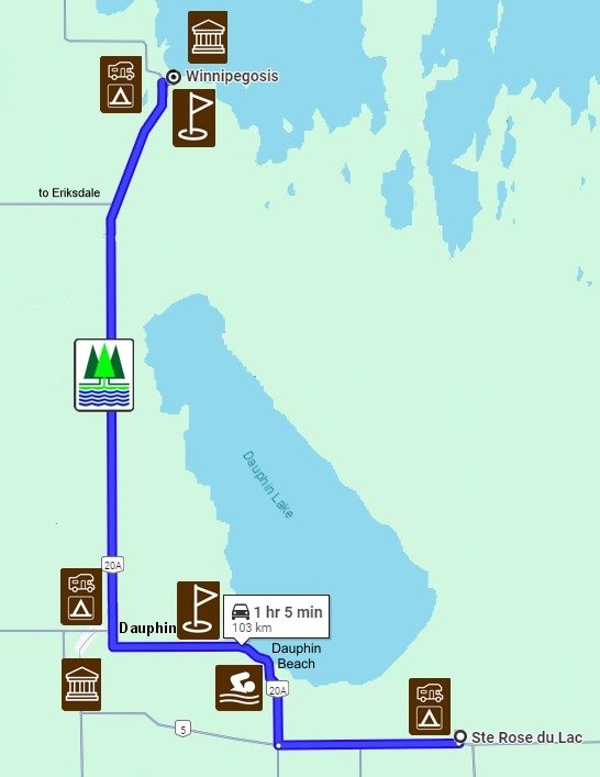


From Winnipegosis, continue north on Hwy 20. The highway travels through a less populated parkland with some agricultural areas, through reserve land at Camperville, then turns west through forest and some agricultural areas. There is a junction turning north on Hwy 10 again which will bring us into Swan River. Turn right on Hwy 10 junction shortly after you enter the town. On your right, you will see the Tourist Information area with their huge swan. We will be staying at the Swan Valley Museum on the northern edge of town.
137 km travel


Activities
Experience Magnetic Hill - Swan River (check directions)
The road west of The Pas is being upgraded. To bypass this rough section, head west on on MB Hwy 77 just north of Mafeking. This section of Highway goes primarily through the boreal forest and pops out at Hudson Bay, SK. There are not many communities along this drive. Hudson Bay is a good mid-trip break. There is a great 9 hole golf course and the Al Mazur Heritage Park. Within the park, there is a collection of John Deere tractors. From Hudson Bay there is more travel along the edge of the forest and then some nice agricultural areas.
302 km travel
Swan Valley Museum

Hudson Bay Golf Course
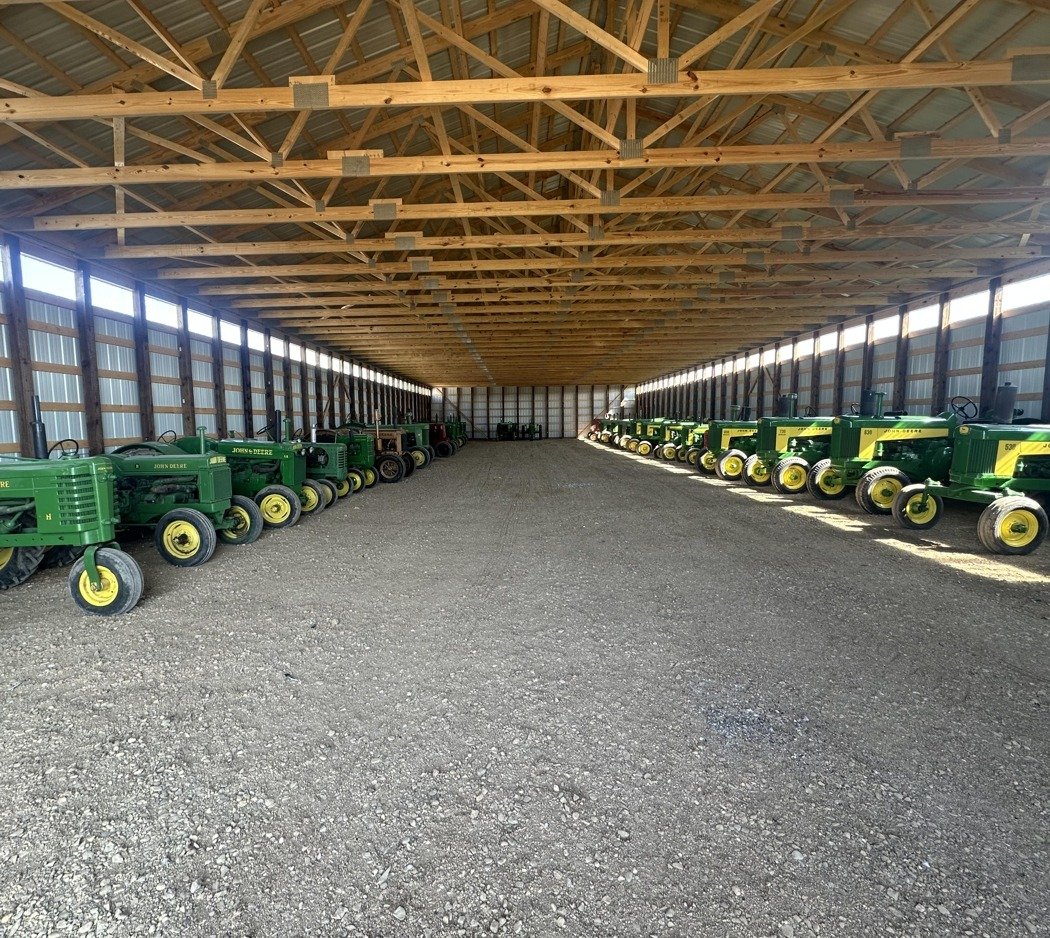
Hudson Bay - Al Mazur Heritage site - John Deere tractor collection

Camping: Pasquia Regional Park

Pasquia Regional Park Golf Course
Golf
Hudson Bay Golf
Pasquia Reg Park Golf
Museum / History
Pasquia Regional Park - Big Bert prehistoric display
Activities
Swimming
Walking
Nature


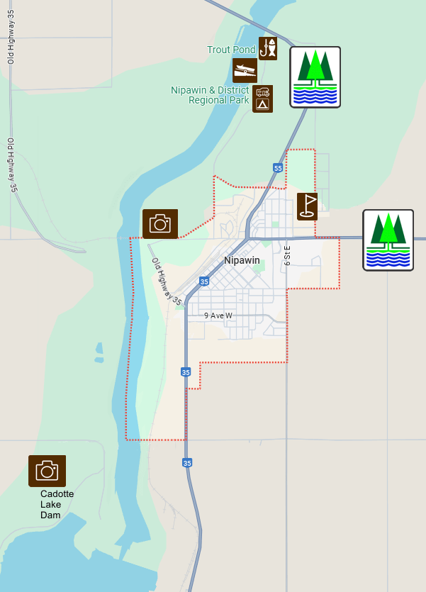
Travel today is through mostly agricultural area. We will travel north through Carrot River, turning west at the junction of Hwy 55. Between Carrot River and Nipawin you can find Rolling Pines Golf & Country Resort Course. It is a little way off the highway but not far. A nice stop for a 9 hole break but be sure you use a cart! Nipawin is the next community which is a base for lots of fishing in the two lakes, Cadotte Lake and Tobin Lake, formed by hydro electric dams. Some record size fish are caught here. A short distance from Nipawin you will come to the tiny community of Love, SK. Love has some very unique signposts for their streets and a wedding chapel. Mail such as wedding invitations are sometimes sent to the post office in Love just so that they can get mailed out with the unique Love postmark. We will pass by several small commuities and then arrive in Prince Albert which is one of the larger communities along the route.
190 km travel

Rolling Pines Golf Course

Cadotte Lake Dam - Nipawin
Large Refueling Station at Choiceland, SK.
Camping
Prince Albert Exhibition Grounds Campground
Golf
Cooke Municipal Golf Course
Evergreen Golf Course
Museum / History
There are 4 museums in Prince Albert
Activities
Shopping
Nature
From Prince Albert, we continue along Hwy 55 to Shellbrook where we head north approx 5 km before the highway turns north west to Canwood. The Canwood Regional Park has a great little 9 hole golf course, but watch out with bigger units as the parking lot is small. Just SW of Debden is a great beach on Morin Lake but the road is gravel. North of Debden the highway goes through the forest. Big River is next on this NW trek. We will be camping at the Big River Regional Park. The next day starts out with a trail ride into the west side of Prince Albert National Park, the hope is to encounter a free roaming herd of wood buffalo. After the ride we mount up the RVs for our drive to Northern Meadows Golf Resort west of Goodsoil for the evening and supper. From Goodsoil to Northern Meadows is a few kms on a gravel road.
132 km travel


210 km travel
The day's travels will include numerous lakes. If you would like to spend a litle bit of time fishing from shore, Cowan Dam north of Big River is a great place to pull off the highway and take some casts. Cowan Dam is what creates Cowan Lake, known for it's Northern Pike and Walleye fishing, similar to Green Lake where the highway turns west into Meadow Lake. The forestry industry is obvious in this region. Northwest of Meadow Lake is Meadow Lake Provincial Park with multiple lakes for swimming, fishing, water skiing, and beach time. Goodsoil is near the west entrance to the Park. Northern Meadows and Meadow Lake have excellent 18 hole golf courses. We will be camping at Northern Meadows.


Camping
Northern Meadows Golf - full service sites
Supper
Northern Meadows Golf
Sani Dump

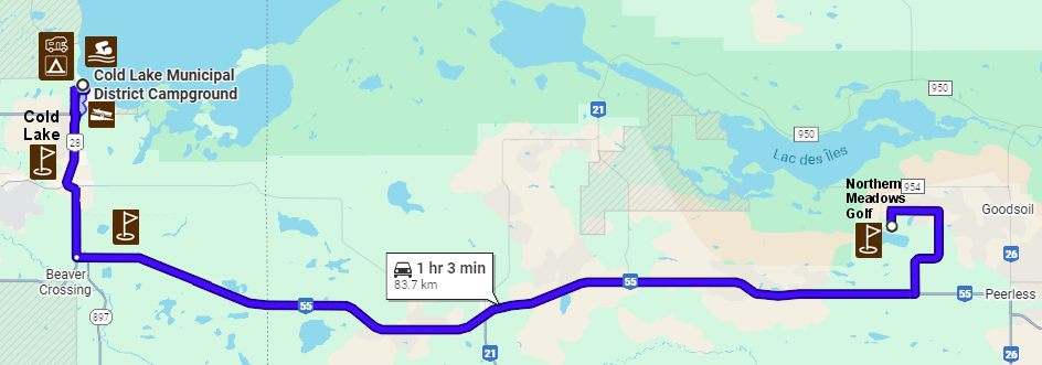
75 km
It is just a short hop from Northern Meadows Golf Course across the border into Alberta and the City of Cold Lake. Cold Lake is home to CFB 4 Wing, one of Canada's fighter bases and pilot training facilities. The community is an amalgamation of 3 communities, Cold Lake, Grand Centre and Medley. Cold Lake North has camping, a beach and a marina. There is a museum at the top of the hill between the two residential areas that showcases the military history as well as First Nations and the Oil & Gas Industry. There should be lots of time for relaxing here today, or exploring around the town.
Camping
Municipal District Campground
Sani Dump
Cold Lake Energy Centre


Cold Lake Air Force Museum

Cold Lake Marina
Beach,
Zipline into the Lake
Bird's eyeview of marina
Golf
Grand Centre Golf Course
Cold Lake Golf & Winter Club
Lac la Biche Golf Club
Museum / History
Cold Lake Air Force, Oil & Gas, 1st Nations Museum
Aircraft displays at various locations
Activities
Swimming,
Beach Time
Splash Park
Zipline into Lake
Marina Stroll
Watching aircraft
Nature
Hiking Trails
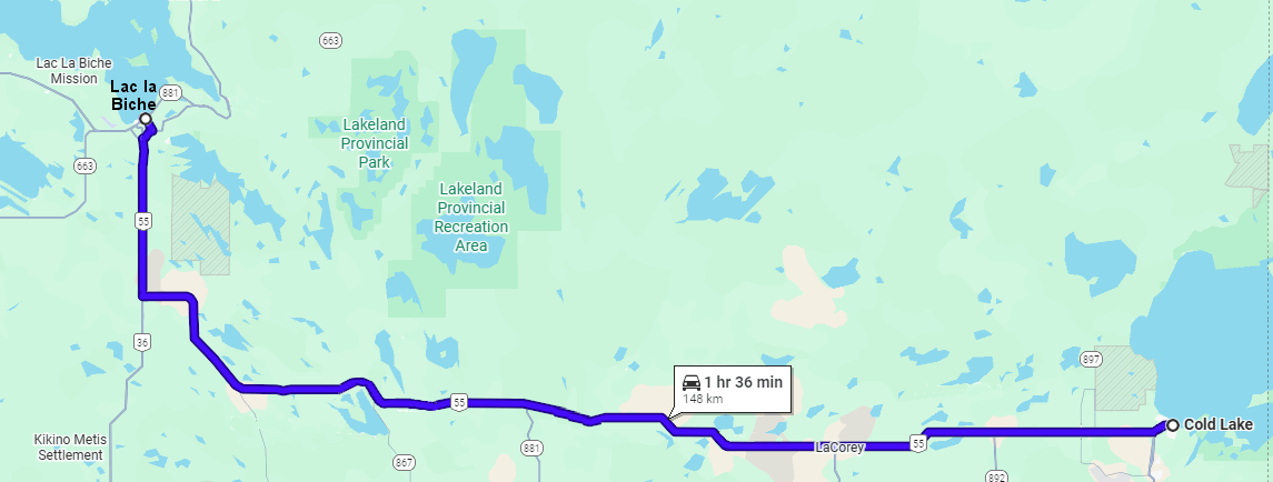
148 km
Another day of travel through forest and agricultural land to reach Lac la Biche. You probably noticed a lot of oil and gas activity leaving Cold Lake and also here as well. The Lac la Biche Mission historic site is a very interesting place to visit. It is a little way out of town to the west so you could stop there tomorrow as well. The town of Lac la Biche has a nice beach park area, a nice little museum/visitor centre and lots of fishing opportunities as well as one of the top golf courses on the highway.

David Thompson Mounument

Fur trade Animals

Cold Lake Beach
La Corey Oilfield parking lot

Lac la Biche Golf & Sir Winstion Churchill Park

Lac la Biche Mission
Camping: Bold Centre Campground
Sani Dump: Bold Centre
Golf
Lac la Biche Golf
Museum / History
Lac la Biche Mission Historic Site
Lac la Biche Museum & Info Centre
Activities
Beach and playground north of the museum
Nature
Bird watching
Lots of Waterfowl in area.

This section is a good example of why the highway is called the Northern Woods & Water Highway. There is an abundance of trees and lakes which are great for relaxing the soul. Lots of oxygen in the air. The Athabasca golf course is a premium golf course that you may want to take in 9 holes for a break in today's travels.
From the Junction of Hwy 63 & 55 which goes north to Fort McMurray to the junction of 55 and 63 going south to Edmonton you could see the heaviest truck traffic, both oil & gas and forestry. It is a short section of only 24 km. The community of Grassland is the place that a lot of vehicles take on fuel and snacks for the drive north.
228 km travel
Camping: Big Fish Bay
Supper:
Sani Dump: Big Fish Bay

Boreal Forest Drive


Athabasca Golf

Heavy Fort McMurray traffic refueling & food
Golf
Lac la Biche Golf
Athabasca Golf
Slave Lake Golf
Museum / History
Lac la Biche Museum
Activities
Fishing
Boating
Swimming
Nature
Wildlife spotting
Water time relaxation

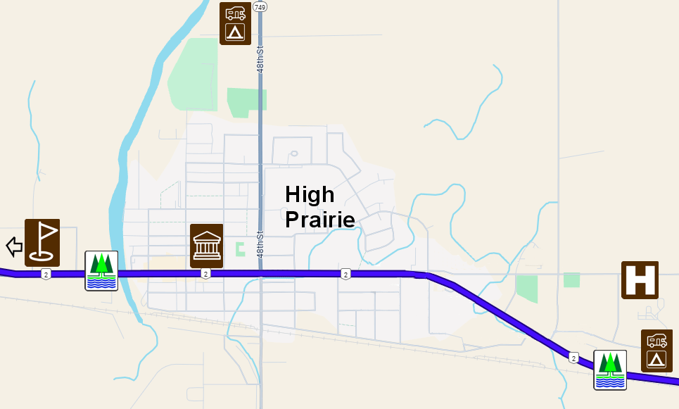
High Prairie is the east access to the rich agricultural region of NW Alberta and NE BC known as the Peace Country because of the Peace River that runs through the region before turning north into the Slave River then onto Great Slave Lake and the Arctic Ocean. This region gets extended hours of sunlight during the summer but less in the winter due to its location. Primarily an agricultural region but in recent years the oil & gas and forestry industries have become more important economic drivers of the region. The travel day will skirt the southern shores of Lesser Slave Lake, the 2nd largest lake in Alberta. The lake is 82 kms long x 20 kms at its widest point. It is full of fish, has great beaches and a multiude of campgrounds along the southern shores. There is history of the fur trade starting from the northwest corner and the Peace River Trail. There are two native reserves west of Slave Lake that we will pass through today.


High Prairie Golf Course
Camping
High Prairie Elks Campground
Supper
High Prairie Elks Campground
Sani Dump
Stampede Grounds
116 km travel

High Prairie Elks Campground
Kinuso Elevator Museum
Commercial Fishing Boat at Faust

First nations influence with multiple reserves in area.

Shaw's Point Beach on NW near Grouard
Golf
Gilwood Golf 18 holes - Slave Lake
High Prairie Golf Club - 9 holes
Museum / History
Kinuso Elevator Museum
Native Cultural Arts Museum - Grouard
High Prairie Museum
Activities
Swimming
Fishing
Beach Time
Nature
Hiking Trails
Bird watching
Wildlife observeing

Proceeding west and then north from High Prairie, we pass through numerous small towns, McLennan was the birthplace of the Northern Woods and Water Highway as a gentleman from that community worked diligently to get the route recognized by the provinces of MB, SK, and AB. Donnelly and Falher are two strong French communities in the area. Falher is known for its honey. There are four golf courses, 3 - 9 holes (High Prairie, McLennan and Nampa) and an 18 hole one just west of the town of Peace River. Peace River town was established as a place to ferry across in the early days of the fur trade and well-known gold miner and businessman, Twelve Foot Davis, was instrumental in the town's growth. His gravesite is on the east hill outside of town.
129 km travel


McLennan Birdwalk
Camping: Rendez Vous RV Park, East Hill Peace River
Supper: TBD
Sani Dump: Rendez Vous RV Park

Donnelly back of Street Signs

Heart River Golf Course - Nampa

12 foot Davis
Golf
Farmington Golf
Dawson Creek Golf
Fairview Golf Course
Mighty Peace Golf
Museum / History
Dawson Creek Museum
Walter Wright Pioneer Village
Dawson Creek Art Gallery at Elevator
Peace River Museum & Archives
Activities
Photo Op at Mile Zero Post
Dunvegan Historic Site
Boating on the Peace
Fairview Music Festivals
Nature
Bear Mountain wind farm south of DC
Peace Valley - Taylor, Dunvegan, Peace River
Travelling south westward through the Peace Country the highway crosses the Peace River at several locations. Dunvegan Bridge is another historic site with a campground and museum worth stopping at. At Rycroft, the Highway makes an abrupt turn to the west into BC. Check your fuel at Baytree just before the border. Dawson Creek is Mile Zero on the Alaska Highway which was hastily built during World War 2. Stop at the info centre on the east side of the city and learn more history of the Highway, possibly tour the Walter Wright Pioneer Village while in town.

233 km travel
Mile Zero Post

Walter Wright Museum

Lac Cardinal Pioneer Village

Fairview Golf & Camping

Bay Tree - 25 km to Cheaper Fuel

Fairview Golf & Camping
Camping: Northern Lights RV Park
Mile Zero Campground
Supper: TBD
Sani Dump: Rendez Vous RV Park

Dunvegan Bridge south of Fairview
Golf
Dawson Creek Golf
Mighty Peace Golf
Fairview Golf Course
Museum / History
Peace River Museum & Archives
Lac Cardinal Pioneer Museum - Grimshaw
RCMP Museum - Fairview
Mile Zero Museum - Dawson Creek
Dawson Creek Art Gallery at Elevator
Walter Wright Pioneer Village
Activities
Photo Op at Mile Zero Post
Dunvegan Historic Site
Fairview Music Festivals
Nature
Bear Mountain wind farm south of DC
Peace Valley - Dunvegan, Peace River
We start south on Highway #97, travel 21 km to the junction of Hwy #57 to Tumbler Ridge. This road is paved but has lots of elevation changes as we head into the Rocky Mountains. After finishing in Tumbler Ridge we will travel northwest on Hwy 29 past Gwillim Lake Provincial Park to Chetwynd . Tumbler Ridge has lots of hiking trails and waterfalls in the area as well as a great museum and golf course. The region has been recognized as a Global Geo Park. The town was originally developed as a planned community to support the coal mining industrywhich has several mines in the region.
118 km travel


Camping
Tumbler Ridge
Supper
Sani Dump
Tumbler Ridge

From Tumbler Ridge we head northwest on Hwy 29 past Gwillim Lake Prov Park and on to Chetwynd. Chetwynd holds an International Chainsaw Carving each year in June. There are close to 200 chainsaw carvings around the community. Most of them were competition winners in previous years.
201 km travel


Gwillim Lake Prov Park
Chetwynd Chainsaw carvings

Highway view

Azouzetta Lake and campground
Camping
Azouzetta Lake
Supper
Azouzetta Lake

Golf
Museum / History
Tumbler Ridge Museum
Chetwynd Museum
Activities
200 Chainsaw Carvings - Chetwynd
Nature
Boreal Foest drive
Pine River roadside

From Azouzetta we continue through the Pine Pass, a scenic drive running alongside the Pine River. There isn't a lot of people living along this picturesque drive. Prince George is located at the junction of Yellowhead and NWW Highways with the Yellowhead being the connection to the West Coast at Prince Rupert. Prince George is the largest community along the Northern Woods & Water Highway. It has a forest based economy and is a logistics hub for the rail industry. The Central BC Railway and Forestry Museum is located in the City near the confluence of the Nechako and Fraser Rivers. There is a winery in the city that you can go to enjoy a tasting. The Fraser River passes through the city as it turns southward to the coast. The NWW Highway will follow along the eastern banks of the Fraser, darting in and out until just north of Williams Lake.
199 km travel
Camping
Prince George
Supper
TBD
Sani Dump

")

Bijoux Falls

Mountain Wild Flowers

McLeod Lake

The Exploration Place - Gaia Gallery
Golf
Coyote Rock Golf
Williams Lake Golf
Museum / History
Mackenzie Museum
Central BC Railway and Forestry Museum
Activities
Wine Tasting
Exploration Place Museum & Science
Nature
Chasm Ecological Reserve
From William’s Lake we will travel north to Quesnel which is still on the Gold Rush Trail. We will spend a couple of nights at Robert’s Roost resort on Dragon Lake on the southern part of Quesnel. This lake offers excellent trout fishing in the spring and fall.
121 km travel
Camping: Roberts Roost Resort on Gook Road
Supper: Roberts Roost Resort
Sani Dump: Roberts Roost
Hixon Falls

Quesnel Waterwheel
Billy Barker
Robert’s Roost Resort
Golf
Several courses around Prince George
Quesnel Golf Course
Museum / History
Activities
Hiking
Banks of Fraser River
Nature
Hixon Falls
Rather than taking the RVs to the Barkerville Historic Town 90 km east of Quesnel and back, we will bus there for the day and return to Robert’s Roost Resort for the 2nd evening. This is a long day, the bus starts in Quesnel at approx. 7 am and arrives at Barkerville at 8 am. We will have breakfast on site. There will be wagon rides and a theatre performance during the day and an early supper on site before returning on the bus to Quesnel at 6 pm.
Bus Trip

Breakfast & Supper: Barkerville
Barkerville Hattery
Blacksmith Demonstrations
Interpretive Tours in Costume
Stagecoach Rides
Museum / History
Barkerville Historic Town
Activities
Interprerative Tours
Stagecoach Rides
Blacksmith Demonstrations
Theatre Presentation
Nature
The day's travel is continuing through the historic Cariboo Gold Rush area. We will travel through forest areas with McLeese Lake about halfway through the drive. McLeese Lake is a very attractive lake with an outdoor Information Centre. There is not much public access to the lake, as most access to the lake is through the private campgrounds. There is a 1st Nations Heritage Site located 35 km north of Williams Lake.
We will be overnighting at the Williams Lake Stampede Grounds. Just kitty-corner across the intersection of the highway by the campground is Scout Island Nature Walk which is a nice place to go for a relaxing walk and see the birds and local wildlife.

118 km travel


Xatsull Heritage Village

Museum / History
Cowboy Museum
The final day of travel is along some of the historic gold rush trail passing through communities named after miles from the Lillooet trail head, ie. 70 Mile House, 100 Mile House, 108 Ranch, etc. You will pass through Lac la Hache which claims to be the longest town in the Cariboo. The lake is 12 miles long with stores, resorts, and cabins along its length. 108 Ranch has a superb golf course and excellent dining. 100 Mile House has the Bridge Creek Falls, in town just a short walk from Hwy 97. Chasm is a unique geological formation. In Clinton, there is history and antiques, bringing you to the last stop of the tour, at the Historic Hat Creek Ranch at the junction of Hwy 97 & 99 to Lillooet. Shortly before you reach our destination you can find great food and a farm market at the Horsting's Farm Market as well as the Desert Hills Ranch Taco Stand.
A short distance to the east of Cache Creek on Hwy 1 is the McAbee Fossil Beds and interpretive trail.

204 km travel


Bridge Creek Falls - 100 Mile House

Golf
108 Ranch Golf
Your content goes here. Edit or remove this text inline or in the module Content settings. You can also style every aspect of this content in the module Design settings and even apply custom CSS to this text in the module Advanced settings.